How to Re-Locate Setting Out Points Fast on Any Site
The problem nobody talks about: points that vanish
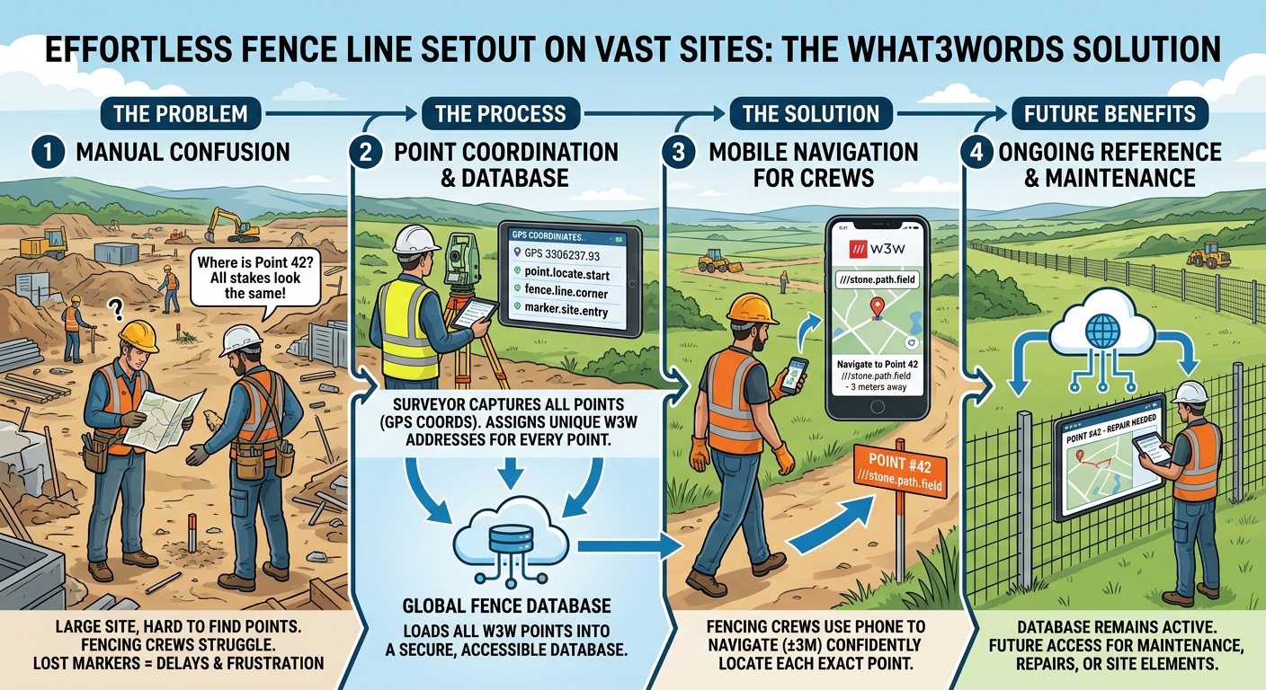
Setting out a fence line across a large site sounds straightforward on paper. The surveyor places the points, marks them up, and hands over. Job done. Except it rarely works that cleanly.
On a big civils project, a solar park, or any sprawling development site, the distance between points can be vast. Ground conditions change. Markers get knocked, buried, driven over, or simply lost in long grass. By the time the fencing crew arrives — often days or weeks later — a significant number of those carefully placed points have effectively disappeared.
What follows is frustrating and expensive: crews walking the line hunting for markers, supervisors fielding phone calls, surveyors being pulled back on site to re-establish what was already done. The survey work was correct. The data existed. But nobody could get to it quickly in a usable form.
This is not a minor inconvenience. Lost or hard-to-find setting out points cause delays, rework, and on tight programmes they can cascade into genuine cost overruns. The fix, it turns out, is less about better markers and more about better data.
What3Words changes the game for field crews
What3Words divides the entire surface of the earth into 3-metre squares and assigns each one a unique three-word address. It works offline, it works on any smartphone, and it requires no specialist training or equipment to use.
The key insight for setting out is this: if every coordinate point on your schedule has a What3Words address attached to it, any member of the team — fencer, civils operative, site manager, maintenance engineer — can open the What3Words app on their phone, tap the address, and navigate straight to within three metres of that point. No total station. No GNSS receiver. No specialist.
Three metres is close enough to find a peg, a pin flag, a paint mark, or a ground spike. It takes the searching out of the equation entirely.
The process: from CAD to crew in a clean database
The approach works like this:
- Start with the coordinate schedule. Whether it comes out of a CAD package, a design model, or a spreadsheet of grid references, the raw data is the starting point.
- Process the coordinates. Each point is cleaned, checked and structured into a consistent format. Duplicates, ambiguities and labelling inconsistencies are resolved before anything goes on site.
- Generate a What3Words address for every point. This is done programmatically — each coordinate is converted into its unique three-word location reference. No manual lookup, no room for transcription error.
- Load everything into a shared database. The point number, its coordinates, its description, and its What3Words address all go into a single, accessible record. This might be a shared spreadsheet, a web-based tool, or a project-specific portal — the important thing is that it is accessible to the people who need it.
- Set out on site with GNSS. Survey-grade equipment is used to place the physical points to the required accuracy. The database record confirms exactly where each one sits.
The result is that the fencing crew, the civils team, the site manager, or anyone else authorised to access the database can search for a point by number or description, tap the What3Words address, and walk straight to it. No radio calls to the surveyor. No guesswork.
Why this matters on a large fencing project specifically
Fencing is a good example because the challenges are particularly acute. Fence lines on solar parks or large infrastructure sites can run for several kilometres. Points might be spaced at irregular intervals to follow a boundary, avoid obstacles, or hit specific design features. The crew installing the fence may not be the same crew who was on site when setting out happened. Subcontractors change. Programmes slip.
On a site like this, confusion is almost the default state. Which peg is which? Where does the line change direction? Is that marker for the fence or for something else entirely? When everyone is working from paper drawings and photographs of pegs in a muddy field, the potential for error is significant.
A structured, searchable database with What3Words navigation collapses that confusion. Every point has a name, a description, and a phone-navigable location. The crew knows exactly what they are looking for and exactly how to get to it.
The database does not expire when the project ends
This is the part that most site teams do not think about at the time, but almost always wish they had.
Once the fence is in, the database of setting out points does not become redundant. It becomes a maintenance asset. Years later, when a section of fence needs repairing, an access gate needs relocating, or a boundary dispute needs resolving, the original point locations are still there — accurately recorded, with What3Words navigation intact.
The same applies across other site types. On a solar park, the original setting out points for panel rows, cable routes, and equipment foundations remain locatable for the life of the asset. On a civils project, buried infrastructure coordinates stay findable even after the surface is finished. For handover, for audits, for future maintenance contractors who were not on the original project — the database is a lasting record that keeps paying back.
This is the difference between a survey that produces a report and a survey that produces a living, usable data asset.
The same approach works on any site
The fencing example is instructive, but the process applies equally well to:
- Solar parks — row positions, inverter foundations, cable route markers, perimeter points
- Large civils projects — drainage runs, pile positions, structure corners, highway alignment points
- Utilities and infrastructure — any buried or semi-permanent feature that needs to be re-found reliably
- Land and estate management — boundary markers, feature positions, access points
The common thread is that there are coordinates, there are physical points on the ground, and there is a recurring need for different people at different times to find them quickly and confidently.
Getting this set up on your project
If your project involves setting out at scale — particularly where multiple crews or trades will need to re-locate points over time — it is worth building the What3Words database step into your survey workflow from the start, not as an afterthought.
The coordinate processing, What3Words generation, and database build all happen before anyone goes on site. The cost per point is modest relative to the time it saves when a fencing crew can navigate directly to a point rather than spending twenty minutes hunting for it across a field.
Streamtech Setting Out offers exactly this — survey-grade GNSS setting out combined with a What3Words database built from your coordinate schedule, so every point placed on site is also permanently navigable by anyone with a phone.
Clean data, placed accurately, findable forever. That is what turns a setting out survey into something genuinely useful for the whole life of the project.
Tired of doing this by hand?
Streamtech Setting Out does it automatically, in one click. Free trial, no card needed.
Try Streamtech Setting Out free